
Above-normal heatwave days are predicted in most parts of central, east and northwest India during this period.

Gujarat on Friday heaved a sigh of relief as the severe cyclonic storm 'Nilofar' further weakened and will have no major impact except moderate rains along with windy weather in some coastal areas of the state.

Exactly a year after the very severe cyclonic storm Phailin struck the state, another storm is heading towards the Odisha coast.
'Very severe cyclonic storm Biparjoy at 2330 hrs IST of 9th June over east-central Arabian Sea near lat 16.0N & long 67.4E. Likely to intensify further & move north-northeastwards during the next 24hrs,' the IMD said in a tweet.

The India Meteorological Department has said that the landfall process of Cyclone 'Biparjoy' has started in Saurashtra and Kutch regions of Gujarat. The landfall process will carry on till midnight with wind speeds reaching a maximum of 140 kilometres per hour, the IMD said.

The IMD DG said there should not be an impression that climate change leads to rise in the temperature, but on the contrary, it leads to erratic weather.

Southwest monsoon, the key to the agriculture driven trillion-dollar Indian economy, on Tuesday brought showers to Kerala bringing much-needed relief to farmers.

The Navy has has kept five flood teams and three diving teams on stand-by in Mumbai, the official said. These teams, trained and equipped for rescue operations, are stationed at various naval areas across Mumbai and can provide early response over a larger area, he said.

The benchmark index on Wednesday surged 314.92 points or 1.05 per cent to close at 30,248.17 on widespread buying spurred by forecast of a normal monsoon this year.

A well-marked low-pressure area over southwest Bay of Bengal intensified into a depression on Thursday morning packing wind speed of 40-50 kmph as it moved towards the north Tamil Nadu coast, the weather office said.

The country can expect normal rainfall during the southwest monsoon season as a positive Indian Ocean Dipole (IOD) and a lower snow cover over the northern hemisphere are likely to counter the evolving El Nino conditions, the India meteorological department (IMD) said on Tuesday.

There has not been a large impact of untimely rain and hailstorm so far in several major wheat-growing areas, and those might have damaged around 3 per cent of the standing crop -- not enough to make a big dent in the expected 112 million tonnes of production in FY24, a senior government official said on Tuesday. Relentless rain pounded most North Indian states all through March. Separately, the chairman of Food Corporation of India (FCI), Ashok K Meena, told reporters the agency was on track to achieve the targeted 34 million tonnes of procurement in FY24 on the back of a strong start to the purchase season from Madhya Pradesh.

El Nino, an anomalous rise in sea surface temperature off the Peru coast, has been observed to often cause the Indian monsoon to flounder, resulting in poor rainfall. Nearly 60 per cent of agricultural land is wholly rain-dependent.

A red alert has been sounded in three districts of Idukki, Thrissur and Palakkad in Kerala.

The cyclone is expected to make landfall on Thursday evening as a 'very severe cyclonic storm' with maximum wind speed reaching up to 150 kilometres per hour, the India Meteorological Department (IMD) said.

Heavy rainfall and high speed wind has badly affected normal life in Bihar in last 24 hours because of cyclonic storm Phailin impact of cyclonic storm. "More heavy rains are expected in Bihar in next 24 hours," a met department official said.
Senior officials of the India Meteorological Department said they were now more confident that El Nino would indeed appear during the second half of the southwest season, compared to April when the last official forecast was made.

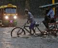
Unprecedented rains and floods in the northern region in the past few days have not only caused extensive damage to lives and property but have also impacted business and commercial establishments. Vegetable prices have gone through the roof in the national capital and many other parts of the country since rains started pouring earlier this month. Traders say vegetable prices would come down only after roads open and skies clear, even as water in the fields will take time to recede.
Though early days, meteorologists point towards a neutral La Nina during the initial phase of the four-month monsoon season this year that starts from June. If this holds true, by the time the rains hit the mainland, it could mean there would be one less reason to worry about the prospects of the monsoon this year. Weathermen said making any accurate prediction of how El Nino will behave and what impact it can have on the progress and distribution of rains is difficult to say at this point. A clear picture will emerge around late May or early June.

The weather system over the South Andaman Sea and the adjoining southeast Bay of Bengal is very likely to move north-westwards and strengthen into a depression by Saturday, the Met Department said.
Taking a lesson from last year's tsunami disaster, sensors are being planted in the seabed to record seismological changes, according to the Indian Space Research Organisation.

Data spanning the years 1951 to 2014 show that temperature and pressure conditions at specific locations in the Arctic region during the pre-monsoon period correlate with the Indian summer monsoon rainfall, points out Charu Bahri.
Taking a sceptical view of MUDRA program, Shiv Sena sought to know when the distressed farmers get help and how does the government plan to curb their suicides.

'Already, the temperature has touched 39 degrees in some parts of Gujarat and now we are in the last week of February.' 'We need to activate the heat action plan from March 1.'

The CII has suggested a 5-point agenda on the measures that need to be undertaken by central and state governments to stave off the adverse effects of a deficient monsoon. Let's find out what this agenda is. . .

The DG said the maximum of four teams of the NDRF have been positioned in Kutch district and the Gujarat government has done an in-depth evacuation exercise as part of which fishing boats have been anchored, big ships have been sent to the high seas so that they are not affected by the tidal waves, more than 4,000 hoarding have been taken down so that they don't become deadly flying objects as strong winds blow.

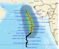
Cyclone 'Biparjoy' has an extensive damaging potential and it is likely to impact Kutch, Devbhoomi Dwarka and Jamnagar districts of Gujarat the most, the India meteorological department said on Tuesday.

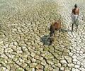
Officials in the weather department said the monsoon is expected to be below normal because of the El-Nino effect.

Rainfall in August is predicted to be below normal (less than 94 per cent of LPA), but the situation is expected to improve comparatively in September, the IMD said.

The World Meteorological Organisation/Economic and Social Commission for Asia and the Pacific Panel on Tropical Cyclones, at its twenty-seventh session held in 2000 in Muscat, Oman, agreed to assign names to the tropical cyclones in the Bay of Bengal and Arabian Sea.

No lives were lost after cyclone Biparjoy made landfall. Preparations for Biparjoy were not only extensive, they were also telecast far and wide. Ahead of the cyclone's landfall, Shyam G Menon observes there was considerable publicity on how much the government was geared up to face the storm and its aftermath.

Rain or thundershowers have also been predicted in south interior Karnataka and at a few places over Coastal Karnataka and North interior Karnataka.

As many as 12 teams were deployed and five teams were on standby in West Bengal while additional teams are also in readiness if required.

Between June 1 and July 28, about 32 per cent of the 685 districts in the country did not receive adequate rainfall.

'How much rain fell on June 16 and 17 is NOT known because the area of Kedarnath is not covered by the Indian Meteorological Department,' M Shashidhar Reddy, vice chairman of the National Disaster Management Authority tells Sheela Bhatt. Because of this, the NDMA will not know "what exactly happened over there, in and around the Kedarnath temple."

An alert of "very heavy" rainfall in Mumbai has been issued by the Indian Meteorological Department's regional centre on Tuesday, with the rains expected to intensify in the next 24 hours.

Riding high on the hopes of a normal monsoon, the agriculture ministry aims to increase foodgrain production by 6.35 million tonnes to a record 298.3 million tonnes in the 2020-21 crop year. The foodgrain output in the 2019-20 crop year (July-June) is estimated at an all-time high 291.95 million tonnes, as per the second advance estimates released by the ministry in February.

The storm would continue to move north-northwestwards, intensify further and reach north Bay of Bengal near West Bengal and the adjoining north Odisha and Bangladesh coasts by the morning of May 26

El Nino is often associated with below average warmer, dry weather across Asia Pacific region.

According to the Central Water Commission, of the 91 major reservoirs in the country, 62 water bodies reported 80 per cent or below of normal storage.